
Enumclaw has one. Buckley has one. Bonney Lake does not. What is it?
Answer: a downtown corridor.
But as of the Nov. 15 City Council meeting, the council is looking at updating the center plans to four key areas to the city – Lake Tapps, Downtown, Midtown and Eastown – to possibly include areas easy for Bonney Lake residents to walk or bike to and shop and socialize at, away from the hustle and bustle of the highway cutting through the heart of the city.
The process for updating the plans for those four areas started in 2014, when the city received a Department of Ecology grant for completing the city’s Watershed and Centers Plan.
Over the last summer, the city and BERK Consulting located, in Seattle, held four public workshops to both give city residents information about planning that’s going on get input from residents about what they’d like to see in those areas.
After compiling that information, BERK presented land use scenarios for the Lake Tapps, Downtown, Midtown and Eastown centers to the council on Nov. 15.
More workshops on the following land use scenarios are planned to be scheduled later this year, and finalization of the plans anticipated in the first quarter of 2017.
BL Centers Plan Alternatives by Ray Still on Scribd
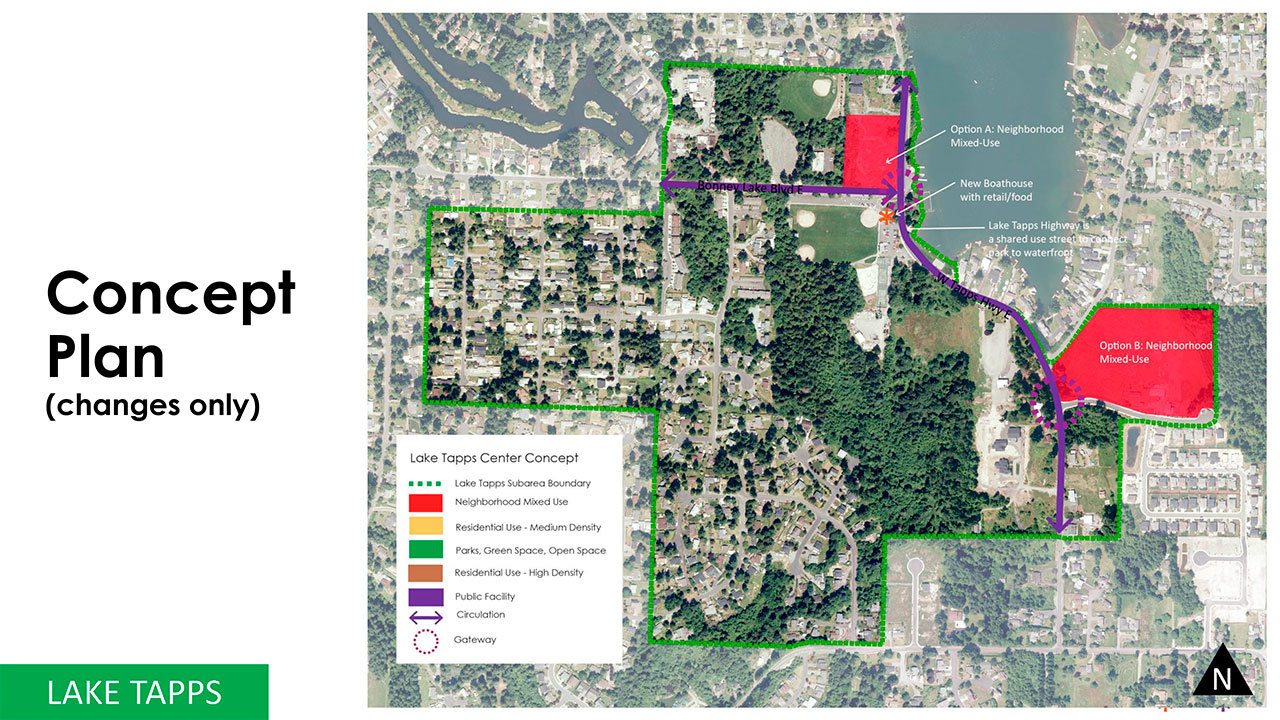
LAKE TAPPS
In addition to the other improvements the council is looking to make at Allan Yorke Park, BERK recommended the city make some changes to the areas around the park as well.
According to Jeff Arango, project lead for these alternative plans, many people who participated in the workshop for the area said they’d like to see the development of some sort of neighborhood commercial area.
The consulting firm recommended two areas, currently vacant and without vested developments, that could be rezoned as Neighborhood Mixed Use to combine residential and commercial spaces.
One area was identified directly north of the main field at the park, right alongside the lake’s western cost.
The second area that could be rezoned is east of the park, close to the southern tip of the lake and east of Church Lake Drive East and West Tapps Highway East.
Arango also suggested to the council the idea of a boathouse close to the boat launch docks that would support a small retail and food shopping area, similar to the Green Lake Boathouse in Seattle.
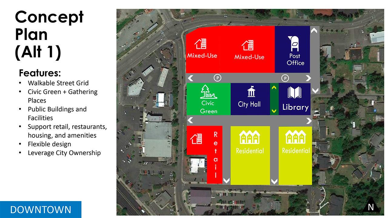
DOWNTOWN
“Similar to Lake Tapps, we’re not proposing a lot of changes of land use,” Arango said.
The only changes BERK recommended the city make to the Downtown Center – land northwest of Angeline Road up past where state Route 410 meets Veterans Memorial Drive – involved the area directly surrounding the current Justice and Municipal Building.
First, Arango suggested an overhaul of traffic circulation in the area by constructing new streets to form a grid to make it easier for cars and people to get around.
“All of these streets would support on-street parking, which would take some of the burden away from the private sector to provide parking, particularly for pedestrian-oriented retail,” Arango said.
There would also be the construction of pedestrian-only alleyways that would connect to the streets, which allows the development for blocks in the area “and make it very attractive for other developers to come in and build some of the local businesses and amenities the community is looking for,” Arango continued.
In workshops, city residents said they really wanted to see a central plaza that could support a number of logical gathering spaces, like a farmers market.
Taking this into account, BERK had some more ideas for a downtown civic campus.
As in the original plan, the city hall building would remain in the center of the downtown area.
The construction of a new city hall could give the Bonney Lake Police Department a chance to house the department in the new building, freeing up the area north of city hall to be rezoned for mixed-use developments.
East of the city hall would remain the library, albeit with an updated building, and connecting the two would be a pedestrian-only alleyway.
On the opposite side of city hall could be a civic green, and the southern area of Downtown could include high capacity residential areas that would support a retail area situated in the southwest corner.
“One of the benefits of this concept is that it’s very flexible,” Arango said. “The land uses are very conceptual, but if the city were to invest in the infrastructure, they can really leverage that investment to get the development that the community wants.”
The model for BERK’s plan is the Civic Campus in Puyallup.
MIDTOWN
“When you take a look at the current plan for Midtown, it has really strong bones,” said BERK consultant Erika Rhett. “It basically talks about creating a transition to more of a mixed-use environment there, improving the identity and creating more connections to development in Midtown and development outside of midtown.”
Rhett said the Midtown improvements focus on protecting the neighborhoods around the area, which is everything along state Route 410 between Angeline Road East and 221st Avenue East.
Before anything else, BERK suggested revising the boundaries by bringing a small part of Eastown, which is past the Safeway shopping complex, into Midtown.
Part of the plan would include the development of pedestrian walkways and streets that would connect this new part of Midtown to the residential area behind Safeway.
“But the main feature of the plan is these mixed-use nodes,” Rhett said. “What we know about Midtown is that, by it’s nature and the types of stores that are there… people don’t go to those stores on bicycles. They’re with their cars and they make big shopping trips and we don’t expect that to be different.
“But in the mixed-use nodes, we might expect a little bit of a different kind of development,” Rhett continued. “People would go to the mixed-use nodes, park once, and there could be places there for people to live there full time, there could be offices there that would bring in office workers… and there would be smaller shops and restaurants.”
The nodes Rhett refers to would be designed like the CitySet area in Glendale, California.
BERK recommended three areas to be turned into these mixed-use nodes.
Area 1 consists of the Wal-Mart and the Bonney Lake Plaza, plus the residential areas to the west. BERK recommended that pedestrian connections in the area could eventually make the area look and function like Kent Station, with a number of stores and pedestrian-oriented spaces.
Area 2 includes the vacant Albertsons shopping complex, which, according to the firm, is a prime area for redevelopment.
Area 3 spans the Safeway shopping complex all the way to the north portion of the WSU residential area. BERK recommended an increase of commercial development in the area.
BERK also recommended that the Cedar View neighborhood be rezoned from R-2 to R-3 to increase the likelihood that the neighborhood is redeveloped, and that a swath of land east of the Safeway lot be included in the Midtown plan and zoned for commercial use.
EASTOWN
Rhett said the current Eastown plan – which includes enhancing the SR 410 corridor, creates alternate routes for local traffic off of the highway, extends city water and service to the area and more – is already very strong.
“What we heard from people is that they want a little more predictability and ease of development in Eastown,” Rhett continued. “They are concerned that by forcing it into a box that would fit with some of the other center’s concepts, that it might not be as successful.”
BERK recommends that the Eastown plan’s subarea plan be updated, but not to fold it into the overall policy for the center.
“We would alter some of the land use and zoning changes to encourage predictability and ease of development, but otherwise kind of going strong as the plan exists now.”
A possible alternative plan for the Lake Tapps center development.

A possible alternative plan for the Midtown area of Bonney Lake.
