Bridging history: A timeline of the Plateau’s important crossings
Published 1:00 pm Wednesday, October 29, 2025
South King County bridges remain in the news, after the reopening of the Kummer Bridge over the Green River following a month-long closure, plus the six weeks prior when it was reduced to one lane.
The SR-410 White River Bridge shut down on Aug. 18 when it was struck by an over-height vactor truck. WSDOT contractor crews worked seven days a week to repair the extensive damage, and it reopened Friday, October 17.
Both the Green and White Rivers are of similar length, about 65 miles long from their source to the Auburn valley floor. Historically, the Green and White Rivers joined together in Auburn, then flowed north through Kent and Renton until uniting with the Black River to form the Duwamish, which empties into Seattle’s Elliot Bay. For over a decade at the turn of the 20th century, King and Pierce County farmers fought a ‘River War,’ as neither faction wanted the White River to flood their fields. A November 1906 deluge forced it south, as the two counties continued to battle in court.
The dispute wasn’t settled until 1913, when, by judicial decree, the White was permanently diverted into the Stuck and Puyallup Rivers, with the combined flow into Tacoma’s Commencement Bay. The course of the Cedar River, which once flowed directly into the Black River, was changed in 1911, after high waters submerged portions of Renton. The next year, Renton dug a 2,000-foot-long, 80-foot-wide canal to reroute the Cedar north, so it flowed directly into Lake Washington. The Black River dried up in 1916, when Lake Washington was lowered nine feet after the Ship Canal, located near Husky Stadium, was opened.
Economic growth in Seattle, Tacoma, and the surrounding towns required that rivers be tamed. Over the 30-year period between 1880 and 1910, Washington State’s population grew 15-fold, from 75,000 residents to 1.15 million. Economic growth requires substantial infrastructure, which demands certainty. Wild rivers embody the essence of uncertainty, prompting each region to harness a river’s power and mitigate its destructive patterns. Neither the White nor the Green Rivers were fully controlled until the Mud Mountain Dam subdued the White in 1948, and the Green was brought to heel in 1961 after completion of the Howard Hanson Dam.
The Green and White Rivers have similar watersheds measuring about 480 and 494 square miles, respectively. Their water sources differ – the Green is primarily rainfall and snow melt, while the White River is fed mainly by Emmons Glacier with smaller contributions from the Winthrop and Fryingpan glaciers.
The Green flows through 12 miles of steep canyon walls called the Gorge. The White was more prone to destructive flooding due to its broader flood plain. As a result, the Green River is crossed by seven public highway bridges before reaching the Auburn valley floor: Kanaskat, Green River Gorge, Kummer, Whitney, Green Valley Road, Auburn-Black Diamond Road, and SR 18. The White River is spanned by only one, the ill-fated, 76-year-old, steel truss bridge that is once again carrying 22,000 vehicles daily between Buckley and Enumclaw.
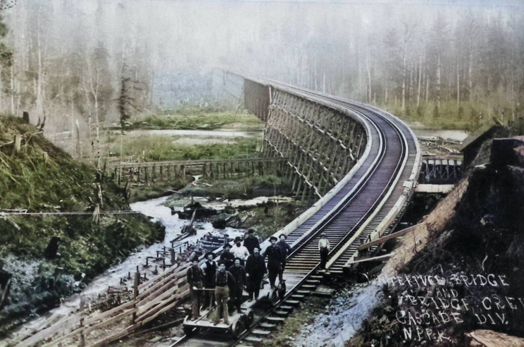
Next week’s photo features the Northern Pacific Railway bridge over the White River in 1907, after the destructive White River flooding of November 14, 1906, mentioned earlier.