
Christopher Nolan’s 2014 film Interstellar is set in a disconcertingly familiar future: The post-apocalyptic science fiction thriller follows a small band of astronauts searching for a new home for humanity among the stars as the Earth has become increasingly uninhabitable.
While the mind-bending physics are certainly showstoppers, it’s the scenes of ecological disaster at home that have become more haunting with time. In one iconic scene, a baseball game is interrupted by a massive cloud of sand sweeping across the Midwest, blocking out the sun and turning a small city into an alien landscape.
Interstellar’s terrestrial visuals were seemingly prescient when it came out in October 2014, as it was released the same year wildfires swept across much of Washington state, charring nearly 387,000 acres of land. The following year, more than two and a half times that land would be swallowed by flames, and in the years since, months of summer sunshine have been lost to hazy skies in Seattle as smoke crawled across the Cascades and choked out the sun.
During the 2015 wildfires, the state was also hit by a severe drought that led to hundreds of millions in lost crops. Salmon in Puget Sound struggled to survive in low, hot summer streams and rivers. Keep 2015 in mind — because many climate scientists expect those conditions to become the norm by mid-century.
A warmer climate driven primarily by human-created emissions is changing the way water moves through and across the state in the form of rain, snow and mountain runoff. Melting sea ice will also raise sea level, forcing some coastal communities to relocate. In southwest Washington, too much water could increase floods and could more frequently submerge Interstate 5. Even inland, drought caused by low mountain snow levels and hot temperatures will likely lead to crop failure and more stress on agricultural water systems.
Chehalis flood threat
The Chehalis River runs from its headwaters outside the small mountain town of Pe Ell in Lewis County. The small town of a few hundred people has a restaurant, two bars, a grocery store and an old Sherman tank on Main Street.
Unlike other rivers in the state, the Chehalis doesn’t start at high elevations before winding its way north through Thurston County and turning westward to enter the Pacific Ocean by way of Aberdeen.
The long, slow river works its way past several small and mid-sized cities that have been built up in its floodplain. During a “pineapple express” in 2007, heavy rains sent the Chehalis pouring over its banks into the surrounding countryside, flooding several cities and cutting off I-5. During rainy winters, the river regularly breaches its barriers and floods portions of Lewis, Thurston, and Grays Harbor counties.
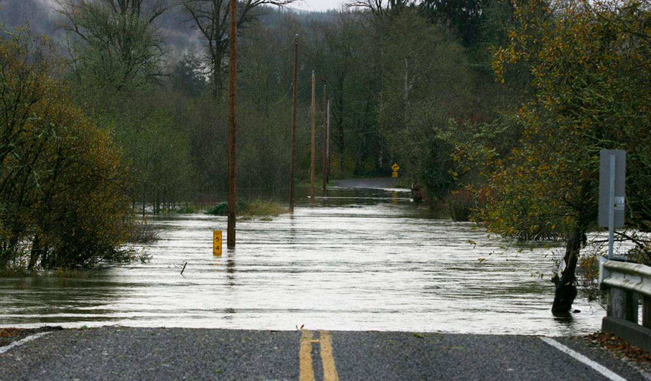
Wenzel Slough Road at Vance Creek in southwest Washington was made impassible on Nov. 18, 2015, due to flood waters. Corey Morris/The Vidette
Guillaume Mauger is a researcher with the University of Washington Climate Impacts Group, one of the organizations on the front lines of figuring out how climate change will affect the Pacific Northwest. Mauger said the Chehalis is fed almost entirely by rain, making it more likely to flood as climate models predict the wet season will become wetter — and the dry season drier — in the state.
“We find that the global climate models show heavy rain events,” Mauger said.
Climate predictions rely on several models to provide a range of possibilities for what scientists expect to see based on how warm the environment gets. Mauger said floods could get 20 percent bigger by the end of the century in some models, meaning 20 percent more water would be flowing down the river during flood events.
In response, the state created the Office of Chehalis Basin, which is tasked with reducing and preventing flooding along the river. In 2016, the office released a sweeping report outlining different options, including building a dam near Pe Ell that would hold back water during floods. This was supported by cities near Pe Ell, but has been opposed by communities farther down-river as well as several tribes, which argue a dam could harm salmon and offer limited protection for their cities.
Coastal hazards
Those living on the coast are dealing with water in another way, said Bobbak Talebi, a senior coastal planner with the state Department of Ecology. The state’s Coastal Zone Management program coordinates programs between partner agencies and provides climate adaptation programs for local governments.
“There’s a number of communities that are facing existing consequences of natural hazards along our shorelines, and those conditions will be exacerbated or magnified by changing climate conditions,” he said.
Shoreline hazards are difficult to talk about in broad terms because of conditions specific to every area of Washington’s coast. For example, a low-lying town will need to consider different hazards than a town that’s built along a bluff, but higher sea levels will affect both. Cities like Westport and Ocean Shores are prone to high rates of erosion while the Quinault Indian Nation town of Taholah is being relocated to keep it above sea level and provide tsunami protection.
Several organizations are working to address coastal issues, including the Washington Coastal Hazard Resilience Network, which was funded by a three-year federal grant from the National Oceanic and Atmospheric Administration (NOAA). This grant has allowed the network to analyze nearly 200 locations along Washington’s coasts and run simulations on the impact of rising sea levels. However, the network lacks enough resources to do mapping, which would allow them to create a more detailed picture of future hazards.
This is often left to local governments and communities who take an interest in protecting themselves, and cities like Tacoma or the Jamestown S’Klallam Tribe have been using this data to create local contingency plans. And this might not be a bad thing, Talebi said, because the closer solutions are to the local level, the more they can be tailored for each community’s needs.
“We have some very good examples of communities that are starting to look at how sea level rise will impact them,” Talebi said.
According to data released last year by the network, there’s a 50 percent likelihood sea levels will rise by around 6 inches by 2050, and it will almost certainly rise by around 4.8 inches or more in the same time. By 2100, it’s almost certain sea levels will be around 1 foot higher than they are currently, although measurements can vary by location.
The rate of sea ice melt will also rely on how hot the Earth gets. According to the 2018 National Climate Assessment from the U.S. Global Change Research Program, the Pacific Northwest has warmed nearly 2 degrees Fahrenheit since 1900. All climate models predict a temperature increase between 3 to 7 degrees by 2050, and 7 to 12 degrees by 2080, according to data from the Climate Impacts Group. On top of this, recent research shows how climate change could destroy cloud formations, leading to even greater heating.
Fish feel the pinch
While areas of the state are expected to deal with more water, other areas, particularly parts of the state where rivers rely on snowpack, will end up with less when it’s needed most. This is already affecting agriculture and salmon — and fish in Puget Sound are feeling the pinch.
Rivers in King County rely on a mixture of rain and melting snow to keep their levels at historic levels. Since the mid-20th century, the snowpack in Washington state has decreased by around 25 percent, with warmer winter temperatures turning more snowstorms into rain over the Cascades and Olympics, Dr. Crystal Raymond said during a presentation in Carnation last October. Much of the snow that does fall is “warm snow,” meaning it falls when the temperature is between 27 to 32 degrees. Predicted temperature increases will all but wipe this out, Raymond said.
Summer stream flow volumes have also decreased around 20 percent on average since 1948. This is likely to continue as hot summers continue, and lower and hotter rivers and streams will hurt native salmon species that rely on cool water to survive.
Salmon runs have been struggling with plunging numbers in recent decades. In a story recently published in Seattle Weekly, state biologists are seeing sockeye dying en masse in Lake Washington, a phenomenon that has increased over the past five years. During these years, researchers saw three of the lowest salmon returns on record, and the 2018 season was the worst ever, with only 3,500 sockeye spawning in the Lake Washington system. The previous low point was 7,000 and a healthy spawning count would be more than 100,000, according to previous reporting from the state’s Department of Fish and Wildlife.
It’s not known why this is happening, but Washington Department of Fish and Wildlife biologist Aaron Bosworth previously told Seattle Weekly that the adult salmon could be coming into contact with diseases in the lake, which could be receiving a boost from warmer water.
“These fish seem to be coming in contact with some diseases, and when they enter fresh water, they die before they get up to the spawning grounds,” Bosworth told Seattle Weekly in January. “We don’t fully understand what diseases — it’s kind of a host of different parasites that attack these fish.”
Hot water in the nearby Lake Sammamish over the summers between 2014 and 2016 are likely what’s behind another decline in a kokanee population unique to that lake, which sits a few miles east of Lake Sammamish. These kokanee salmon, a variety of sockeye, spend their lives in fresh water. The state saw the number of returning spawning salmon drop to 19 in 2018, and this only increased to 100 during the 2019 January count.
This is below a self-sustaining level, and King County and the state are taking dramatic action to save the kokanee, including saving sperm and eggs and potentially raising entire batches of the fish in tanks or ponds until they’re able to spawn. It is thought that warm water in Lake Sammamish forced juvenile kokanee too deep into the lake during summer months — and into areas where there wasn’t enough oxygen to survive.
On top of this, climate change could be hurting fish in ways scientists don’t fully understand. An example of this is documented in research released in December by the University of Washington, showing that higher levels of CO2 in the water could be killing salmon’s sense of smell and making them less able to react to predators. Higher levels of night light in urban bodies of water like Lake Washington could also be making it easier for predators to find young fish.
As an important part of the ecosystem, salmon provide food for people, are an integral part of First Nation’s culture, provide valuable nutrients for streams and nearby trees when they die, and are a favorite food of the starving Puget Sound orcas.
Extreme drought
Looking east of the Cascades, water plays a critical role in both agriculture and wildfires. A report on the 2015 drought from the state Department of Agriculture laid out its damage estimates, which ranged between $633 million to $773 million. Statewide, agriculture accounted for around $10 billion in crop production and another $15 billion in food processing jobs in 2013.
By the last week of August 2015, around 85 percent of Washington state was in extreme drought status. Irrigators in Kittitas and Yakima counties were hit especially hard. Water rights in the state are generally allocated by a system developed more than 100 years ago. Those who had water rights before 1905 were given senior water rights, meaning their supplies would never be curtailed, while junior water rights holders see their water cut off during droughts.
Massive irrigation districts like that of the Roza Irrigation District sit somewhere in the middle as a pro-ratable water rights holder. This means they don’t get shut off with junior water rights holders, but face water insecurity during a drought.
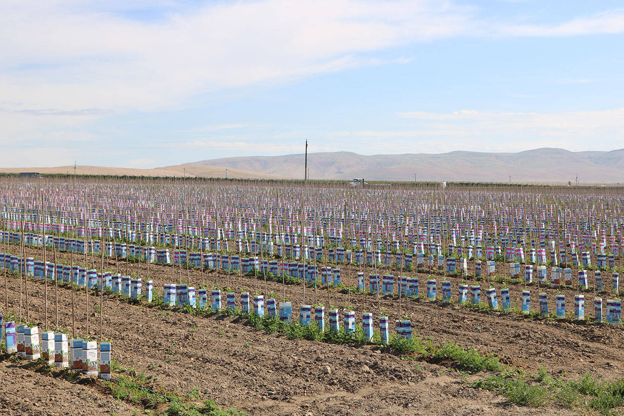
Fruit tree saplings are set in rows in the lower Yakima Valley. They are dependent on irrigation water partially from Kachess Lake, a popular destination for Puget Sound campers. Aaron Kunkler/Staff photo
Precipitation changes are also adding to pest stresses and disease. The National Climate Assessment said the state should develop more robust water markets to help, but that many institutional barriers exist. In particularly dry areas of Washington, farmers could start spacing plants wider than normal and looking at dryland farming, which relies on soil moisture that was created by winter rain.
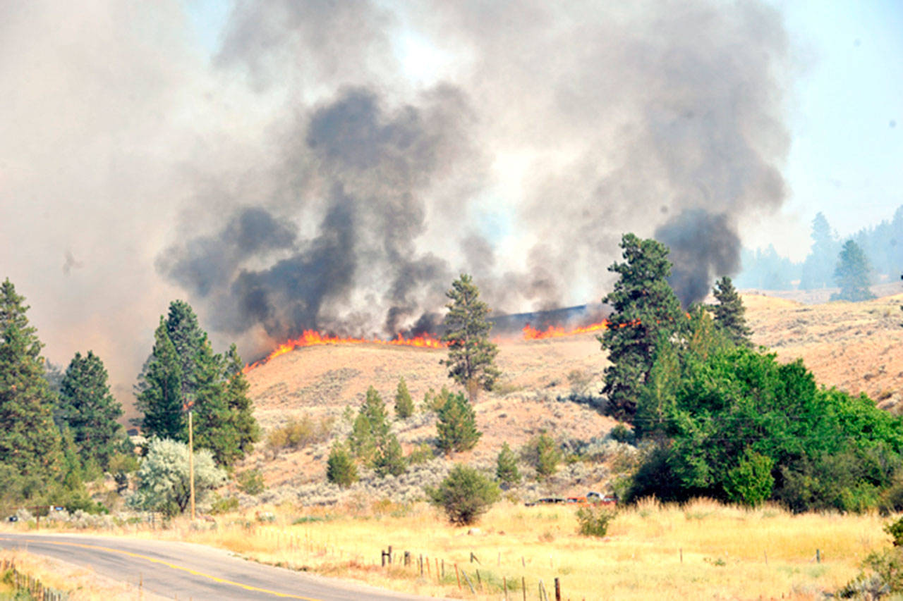
Fighting wildfires
Finally, the most immediately noticeable way the state is changing is felt by the inescapable smoke that has blanketed nearly the entire West Coast in recent years as wildfires roar across dead and dry forests.
Last year saw the highest number of wildfires on record in the state. Department of Natural Resources Commissioner Hilary Franz said around 40 percent of the 1,850 fires struck west of the Cascades. This year’s fire season is starting to look a lot like those of recent years.
“For the coming year of 2019, we will see hotter, drier temperatures, we will see them earlier in the year again, and we will see them for longer time periods,” Franz said.
While the state was doused by historic snowfall and rain in February, this often means grasses will shoot out of the ground during the spring only to wither into tinder-dry fuel for wildfires by late spring, or “grassoline,” as Franz says. This coupled with some 2.7 million acres of diseased and dying forestland in the state provides a perfect storm for wildfires.
Forests across the state are rapidly dying because of disease and pests, which take advantage of trees already stressed by a lack of water. Franz recalled around 100 acres she saw last year that were healthy in April, but by October had succumbed to moss and were either dead or dying.
“Because of that forest health crisis, we are seeing that with any spark or match to it, they quickly become kindling and rapid fires,” she said.
State, local, and federal fire agencies have begun training together in recent years as the threats posed by wildfires continue. Kittitas County fire marshal John Sinclair said that during four of the past six years, they’ve had significant wildfires on the edges of the county.
One of the first of the modern, large wildfires in Kittitas County was the Taylor Bridge fire, which burned in 2012 and turned the county into Silent Hill for days as smoke from wildfires settled into the Ellensburg valley. Sinclair said he is planning on large wildfires to stick around for decades.
“Fire is going to be part of the landscape for the next 40 to 50 years as we implement new strategies and new solutions to our forests,” he said. “A very wise forester told me many years ago: you either manage the forest or Mother Nature does.”
To combat this, Franz has submitted the largest budget increase request in her department’s history to the state Legislature. She is asking for $55 million for wildfire response and for managing forest health. This would include hiring 30 additional full-time firefighters on top of the 43 currently employed by the Department of Natural Resources, as well as implementing a management plan. This plan involves clearing out dead wood and fuels from the forest floor and repurposing it to be used in buildings.
As fires and their smoke are likely to continue into the foreseeable future, Franz said it’s more important than ever for city and rural residents alike to be paying attention.
“Wildfire is not an urban issue or rural issue,” Franz said. “Wildfire is a Washington state issue.”
