
Everyone is familiar with last week’s soggy weather saga: days of unrelenting rainfall that dampened spirits, saturated the Plateau soil, flooded roads and brought swollen ditches, creeks and rivers.
What started as something of a seasonal irritant became an inconvenience. Until it started bordering on the dangerous.
Here’s an overview of what happened when January’s rain pushed into February and, in some cases, simply became unmanageable.
ROAD CLOSURES
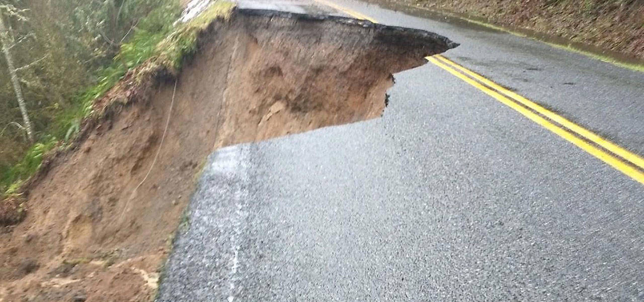
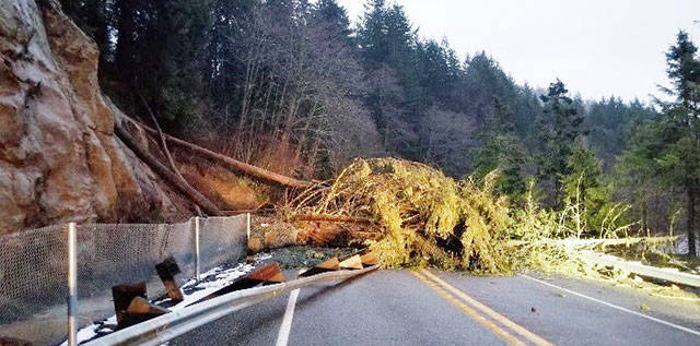
The most dramatic closure came a few miles uphill from Enumclaw, where rain-soaked hillsides took their natural course of action. Gravity prevailed, with mud, rocks and trees sliding across state Route 410.
The popular highway – providing access to the community of Greenwater, neighboring homes and Crystal Mountain Resort – was closed Thursday at Mud Mountain Road. A Department of Transportation spokesman reported that only local residents were being allowed access further east, requiring identification before heading into dangerous territory. Once darkness fell, that stretch of 410 was fully closed.
The overnight, outright closure was “a precaution due to continued rainfall and the possibility of further slides,” the DOT said.
Friday brought new developments as the 410 closure moved downhill to 284th Avenue Southeast. More important was the fact that no one, not even local traffic, was allowed into the area. The DOT tweeted there was a new slide Friday morning, making three in the area.
On Monday morning, 410 was still listed as a “highest impact” area by the DOT. Lanes remained closed in both directions.
Other road closures created detour routes and headaches for commuters.
State Route 162 was blocked just west of South Prairie, shutting off travel toward Orting. Passage was made impossible where South Prairie Creek overflowed its banks and covered the road; the closure began Thursday and continued into Friday. Also in that area, South Prairie Road was closed where it branches off SR 162 due to flooding along that part of the creek.
State Route 165 was closed for a time in Wilkeson and, to the north, state Route 169 was closed in both directions due to high water spilling from the Cedar River.
SCHOOLS AND FAMILIES
The first impacts were felt Thursday when all three local school districts – Enumclaw, White River and Carbonado – sent students home early.
Family schedules continued to be disrupted Friday morning when White River opened schools two hours later than usual and Enumclaw operated on a one-hour delay.
Students at the highest elevation, in the Carbonado Historic School District, were sent home at approximately 10:30 a.m. Thursday. Superintendent/Principal Jessie Sprouse said the decision was made when water was pouring across state Route 165 close to Wilkeson.
Unlike their neighbors, Carbonado kids were on a normal school Friday morning. Spouse was out scouting roads at 4 a.m. and found no reason for delay.
However, a few Carbonado students could not be transported to school. A saturated hillside on Fairfax Forest Reserve Road blocked state Route 165 above the Fairfax Bridge. Also, a large piece of road broke free and simply washed downhill.
Aside from classroom schedules, the abundant rainfall cause a disruption in White River’s athletic calendar. The Hornet boys’ basketball team was scheduled to open the league tournament with a Thursday home game but, with school released early, that game was pushed to Friday.
The White River girls were supposed to host a second-round tournament game Friday, but that contest was moved to Saturday.
Addressing Friday’s late start, the Enumclaw district’s website had this to say: “We had several people driving all over our district before we lost daylight yesterday and then we were up early this morning (Friday). Many areas have receded but several areas have water over roadway. We simply don’t want our buses, student drivers and staff driving in the dark and come across an unmarked area.”
RIVERS AND DAMS
There was water everywhere and much of it was funneled locally into the White and Green rivers. That meant the U.S. Army Corps of Engineers rallied, shifting its “Reservoir Control and Emergency Operations centers” into 24 hours a day operating and sending spotters to monitor conditions on both waterways.
The Corps is responsible for both the Mud Mountain Dam on the White River and Howard A. Hanson Dam on the Green River.
“This is a significant event with the potential to reach inflow levels not seen in over 10 years,” said Jon Moen, a senior water manager for the Corps.
Inflows were predicted to be as high as 27,500 cubic feet per second at Mud Mountain and 22,000 cfs at Howard Hanson Dam. Both inflows were within the scope of what the dams are designed to handle, but Corps staff is charged with managing the reservoir storage space carefully to prevent overfilling the reservoirs.
“Earlier this week we were pushing outflows to reduce both dam’s pools and make reservoir space,” said Western Washington Senior Water Manager Jon Moen. “We are now again storing water to reduce outflows and greatly reduce flood risk on those rivers as the event ramps up.”
Mud Mountain Dam, completed in 1948, exists solely to manage flood risk and typically does not store a pool of water, except during flood events. When completely filled, the reservoir stretches 5.5 miles, covering 1,200 acres.
A landslide on state Route 410 near Greenwater (DOT photo) kept the highway closed to all but local residents for a few days.
