It’s reportedly time for renditions of “Ice Ice Baby,” “Cold as Ice” and “Baby It’s Cold Outside” as the National Weather Service predicts ice accumulations in the next 24 hours or so for portions of northwest Washington and west central Washington.
Or in other words, ice everywhere. Everett, Seattle, Bellevue, Bremerton, Tacoma, Federal Way, Renton, Kent, Auburn, Olympia, etc.
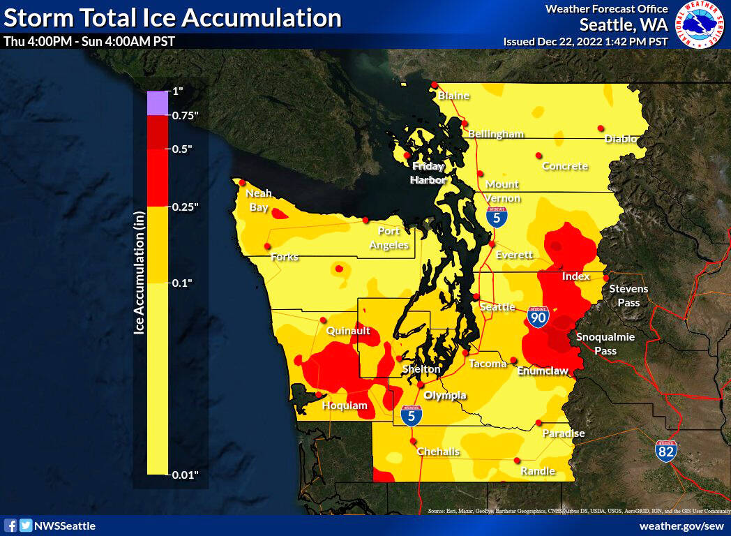
The winter storm warning is in effect from about 4 p.m. Thursday, Dec. 22 through 7 p.m. Friday, Dec. 23, according to the National Weather Service.
• WHAT…Heavy mixed precipitation expected. Total snow accumulations of up to 2 inches and ice accumulations of up to one quarter of an inch.
• WHERE…Portions of northwest and west central Washington.
• WHEN…From 4 p.m. Thursday to 7 p.m. Friday.
• IMPACTS…Plan on slippery road conditions.
• ADDITIONAL DETAILS…This is will be a complex mix of winter precipitation with potentially significant impacts. The best chance for up to two inches of snowfall is across the Hood Canal.
PRECAUTIONARY/PREPAREDNESS ACTIONS…
If you must travel, keep an extra flashlight, food, and water in your vehicle in case of an emergency.
For the latest road conditions in Washington state, call 5 1 1.
The areas that could be impacted include:
Southwest Interior-Everett and Vicinity-Tacoma Area- Admiralty Inlet Area-Hood Canal Area-Lower Chehalis Valley Area- Eastern Strait of Juan de Fuca-Western Strait of Juan De Fuca- North Coast-Central Coast-Bellevue and Vicinity- Seattle and Vicinity-Bremerton and Vicinity- including Lacey, Olympia, Tumwater, Yelm, Grand Mound, Rochester, Centralia, Toledo, Everett, Lynnwood, Marysville, Stanwood, Tacoma, Fife, DuPont, Puyallup, Port Townsend, Oak Harbor, Coupeville, Langley, Shelton, Seabeck, Belfair, Brinnon,
Montesano, Elma, McCleary, Sequim, Port Angeles, Clallam Bay, Joyce, Sekiu, Beaver, Clearwater, Forks, Neah Bay, Ozette, Queets, Aberdeen, Hoquiam, Westport, Ocean Shores, Humptulips, Bellevue, Bothell, Kenmore, Mill Creek, Clearview, Kirkland, Newcastle, Redmond, Sammamish, Issaquah, Seattle, White Center, Tukwila, Renton, Burien, Des Moines, Kent, Federal Way, Bremerton, Poulsbo, and Indianola.
King County message
King County Emergency Management sent out the following message:
“There will be snow and freezing rain tonight (Thursday) and tomorrow (Friday) morning. We want people to stay off the roads. The roads will be dangerous to drive on. Freezing temperatures, loss of power, and downed power lines can also be dangerous.
Changes ahead
While temperatures remain below freezing Thursday and most of Friday, they are expected to go up Friday night and even reach 50 with rain on Christmas Day, making it a wet Christmas not a White Christmas.