Wait, I live near a volcano? Part II | All Things Mount Rainier
Published 9:10 am Wednesday, October 28, 2020
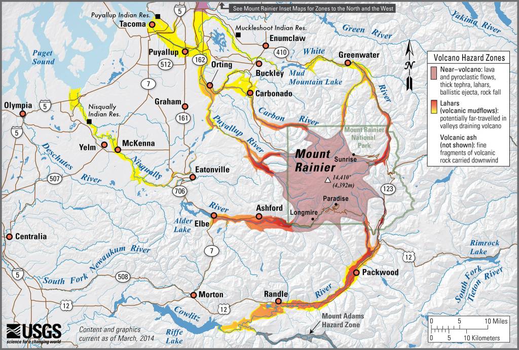


In last month’s column, I wrote about Mount Rainier’s status as a living volcano and its considerable geologic hazards, which places it among the most dangerous volcanoes in the United States. The mountain’s principal hazard is a type of debris flow known as a lahar, which rumbles down river valleys and overwhelms everything in its path. Our home in Enumclaw sits on top of 50 or 60 feet of the Osceola Mudflow, a lahar that rushed across the Plateau about 5,600 years ago. Depending on where you live in terms of the elevation, your home may sit on just a few feet of the flow, or up to about 60 feet of it.
I also wrote that despite these dangers, and recognizing the inherent risks of living nearly anywhere, that Enumclaw is a safer place to live than many other locations. In today’s column, we’ll see how lahars originate, understand why Enumclaw’s risk factor is lower than some other places around the mountain, and examine what folks in at-risk communities are doing to mitigate potential disasters.
Although lahars can trigger suddenly with little or no warning and can occur over a period of minutes or hours, it takes thousands of years for the conditions of a lahar to develop. In the magma chamber deep below the mountain, molten rock rises to the surface, traveling through cracks in the mountain’s volcanic rock.
Magma exiting onto the surface becomes a lava flow, but some magma remains in the cracks. Still hot and containing acidic gases, the magma works slower than a lumbering banana slug as it chemically transforms the surrounding rock from its volcanic origins to a slippery, clay-like material.
At this point, something has to give. As R.P. Hoblitt, J.S. Walder and their colleagues wrote in “Volcanic Hazards from Mount Rainier, Washington”: “Like a house infested with termites, the affected part of the volcano eventually becomes so weak that it collapses under its own weight and generates a debris avalanche” known as a lahar. This is exactly what happened to create the Osceola Mudflow 5,600 years ago, and it explains why the Enumclaw area is relatively safe in terms of future lahars.
Geologists have determined that little or no weakened rock remains in the upper reaches of the Emmons and Winthrop Glacier areas, the points of origin of the Osceola Mudflow. With little of the weakened rock remaining—known to experts as hydrothermally altered rock because of its transformation by water and heat—the chances of another lahar tearing through Enumclaw are low.
More recently (about 500 years ago), another lahar, the Electron Mudflow, began in the upper reaches of the Puyallup River valley and charged through present-day Orting. It blanketed the area with a 16-foot mantle of lahar debris consisting of a wet cement-like slurry of mud, rock, trees, and other debris. Imagine the surprise of construction workers who dug up tree stumps from 16 feet underground while installing infrastructure during an Orting housing boom in the early 1990s.
While the Osceola Mudflow transported nearly all of the chemically weakened rock downslope and removed the hazard of potential lahars from the Enumclaw area, that’s not the case in the upper Puyallup valley.
Chemically altered rock is magnetically weak compared to the mountain’s original volcanic rock; Carol Finn, Tom Sisson, and Marla Deszcz-Pan, co-authors of a research paper with a title longer than a Lincoln Town Car, found large areas of low magnetism, indicating hydrothermally altered rock that could release suddenly and move downslope as a lahar.
They calculated that approximately two billion cubic yards of chemically altered, fragile rock—enough to fill shipping containers that end-to-end would circle Earth six times—sits above the Puyallup River basin in Sunset Amphitheater and near the Puyallup Cleaver. There’s no way to predict when the mass will release, or whether it will be a single event or a series of pulses, but the possibility looms for another Mount Rainier lahar barreling down the Puyallup River valley, this one surpassed in size by only the Osceola Mudflow. Yikes!
Despite the imminent danger, several factors are working on behalf of our neighbors in Orting, Puyallup, Sumner, and the surrounding communities. First, the Pierce County Department of Emergency Management (PCDEM) and the U.S. Geological Survey (USGS) are upgrading the mountain’s lahar detection system. This summer, I assisted with an archaeological survey in the Carbon River area, searching for artifacts in a spot where the USGS plans to install a new lahar detection sensor. We turned up no important finds, giving the USGS the green light to proceed with its work. Second, the sensors and their associated data transfer ties into a system that operates nearly three dozen outdoor warning sirens that line the valley floor from Orting to Commencement Bay. Tested monthly, the sirens will alert citizens of an oncoming lahar. Additional warnings, including the Emergency Alert System and others, ensure redundancy to notify as many people as possible of the danger, signaling that they should move immediately to higher ground. Third, the PCDEM and the USGS spearhead a broad collaboration of city, county, state, federal, and tribal responders that are poised to spring into action in the event of a lahar. I once helped monitor a lahar evacuation drill in Orting for 2,000 school kids and community members, where experts estimate that people have about 45 minutes to make it to a safety zone 30 feet above the valley floor. Puyallup and Sumner residents, who also have annual drills, have an hour-plus to get out of harm’s way. Anyone who is already 30 feet or more above the valley floor will probably be safe from an oncoming lahar and should stay put.
Yes, Mount Rainier is an active volcano with sizable geologic hazards, but despite them, folks living on the Enumclaw Plateau are relatively safe. And while neighboring communities in the Puyallup River valley are at risk of a lahar event, planning and preparation are the best tools. Additional information and loads of resources are available at https://www.co.pierce.wa.us/104/Emergency-Management, or just search “PCDEM.”
Now that we’ve established some of Mount Rainier’s basic geology and hazards, next month we’ll turn our attention to the presence of people on the mountain, beginning over 9,000 years ago. In the meantime, keep your boots dry and your spirits high.
Jeff Antonelis-Lapp is an educator, naturalist, and writer living in Enumclaw since 1982. Tahoma and Its People, his natural history of Mount Rainier National Park, was published this spring by Washington State University Press. Copies are available at https://jeffantonelis-lapp.com/. Jeff would love to hear from you about Mount Rainier. Send your questions and favorite stories to rstill@cmg-northwest2.go-vip.net/courierherald, and subscribe to his blog, too.