The far-reaching effects of Mount Rainier’s retreating glaciers | All Things Mount Rainier
Published 9:25 am Wednesday, March 24, 2021


In last month’s column, we took stock of Mount Rainier’s glaciers, those gleaming blankets of ice and snow that gird the mountain. We learned that park geologist Scott Beason’s recent research found that in the last 120 years, the mountain’s two dozen glaciers have lost over one-third of their area (their coverage) and 45 percent of their volume (their thickness). All have retreated the furthest up the mountainside since record keeping began; eight have melted away entirely since the 1950s. And since all of Mount Rainier’s glaciers spawn rivers that empty into Puget Sound—except the Cowlitz, which flows into the Columbia River—there’s much more to the story. Today, let’s look at some other effects related to Mount Rainier’s retreating glaciers.
When I interviewed then-park biologist Barbara Samora over a decade ago, I asked her about the scientific issues that concerned her most at Mount Rainier. “Aggradation,” she fired back without hesitation. I nodded knowingly, but had no idea what she was talking about. I learned that aggradation is a regularly occurring, long-term process in which glacially-sourced rivers carry sediments produced by glaciers scouring and grinding the bedrock beneath them. If you carefully collect a bottle of water from the White River when it’s running cloudy and let it settle, you’ll notice that the sediment falls to the bottom after a few days. That accumulation is a mini-example of aggradation. You can also see the Puyallup River’s sediment plume as it empties into Tacoma’s Commencement Bay—another example.
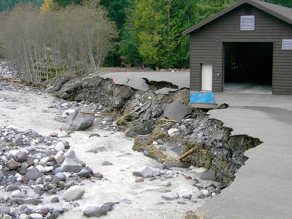
Increased aggradation rates are a big deal because they link to other events. When rivers fill with sediment, their riverbeds hold less water during flood events, forcing the rivers to widen or overtop their banks. A classic example was the November 2006 flood that came on the heels of 18 inches of rain in 36 hours. Creeks and rivers exceeded their banks, causing more than $20 million worth of damage and forcing Mount Rainier National Park to close for six months.
No one knew much about the aggradation process until the 1980s, and even less about the rates at Mount Rainier. That changed when Scott Beason, still a graduate student, studied the mountain’s rivers. With tools ranging from historic maps to state-of-the-art GPS technology, he determined that Mount Rainier’s rivers aggraded at a gradual pace throughout the 20th century, accumulating about four inches of sediment per decade. But when Beason analyzed the data between 1996 and 2006, his heart stopped. The rate had increased to a whopping average of 36 inches over the span.
One way to understand the skyrocketing increase in aggradation rates is to think of the ice and snow on the upper mountain as the “glue” holding glacial moraines and other rock material in place. As glacial ice and snow melts, breaks up, and disappears, greater volumes of rock become available for downslope transport. Whether from heavy rains or other natural causes, gravity eventually prevails, carrying increasing sediment and rock loads into lowland rivers.
To see the results of increased aggradation rates for yourself, take a drive this summer on State Route 410 east from Enumclaw to mile marker 59 and park in the wide gravel lot on the right-hand side of the road. During one seven-year period, the White River deposited over 70,000 cubic yards of sediment at this spot, the equivalent of two cement trucks emptying their payload into the river every day for seven years. At one point, aggradation averaged nearly five feet per decade. When you explore the area, be sure to notice that the river’s bed is 12 to 16 feet above the highway in some places.
Further downstream in nearby Auburn, scientists predict a 50 percent increase in aggradation in the White River over the next 50 years. This could put low-lying homes and businesses at great risk during flooding events.
The sediment from Mount Rainier’s rivers has to go somewhere, and in most cases, its final destination is Puget Sound. Annually, about one million tons find its way into the Sound—enough to fill a building as tall as the Space Needle with a footprint the size of a football field.
Retreating glaciers and the loss of the “glue effect” produces other hazards, too. Heavy winter rains or hot, dry spells in summer can trigger a sudden discharge of ice, water, and rock known as a debris flow. A similar event, a glacial outburst flood, occurs when a reservoir of water and ice breaks loose from a glacier and rushes down valley. Over 30 debris flows and outburst floods have charged down Tahoma Creek on the southwest side of the mountain since the 1960s. No lives have been lost and damage has been confined to within the park, but witnesses have come away with hair-raising tales and unnerving mobile phone videos.
Beason and other experts believe that increased aggradation rates, a higher incidence of floods (ten presidentially-declared disasters since 1990), and a surge in debris flows and outburst floods stem directly from Mount Rainier’s retreating glaciers. They also expect them to continue—and increase in frequency—in the coming years, posing complex challenges for park staff and public officials in low-lying communities.
The once-common practice of dredging rivers to lower the likelihood of flooding is no longer feasible, given the temporary nature of the solution and Federal laws protecting critical habitat for steelhead, Chinook, and coho salmon. Fortunately, a number of creative engineering projects are demonstrating practical solutions and bringing a glimmer of hope for the future. In next month’s column, we’ll take a virtual field trip to look at a few examples. In the meantime, keep your boots dry and your spirits high.