Enumclaw staff shares December flooding data with council
Published 1:00 pm Friday, February 20, 2026
Enumclaw staff presented to elected officials how the December flood event affected the city, and how the city plans to prepare for future emergencies.
However, there is one sticking point that affects when the city can undergo preventative measures: Boise Creek is not within the city’s jurisdiction, and the King County Flood Control District needs to complete a flood map before any engineering solutions can begin.
City Public Works Director Brian Spindor gave the presentation during the Feb. 9 meeting.
According to Spindor, the Plateau area experienced two “definitive spikes” of rainfall on Dec. 8, 10, plus “extremely intense” rain on Dec. 11, all causing Boise Creek to eventually overflow.
At peak rainfall on Dec. 8, nearly a tenth of an inch of rain was falling every 15 minutes between 8 p.m. and midnight, bringing total rainfall levels to about three inches.
On Dec. 10, there was sustained rainfall levels around a 0.06 inches of rain every fifteen minutes, with spikes up to 0.08 inches; total rainfall rose to more than five inches.
Finally, peak rainfall on Dec. 11 rose to about 0.11 inches every 15 minutes, and by midnight of Dec. 12, total rainfall was more than eight inches.
“This is probably the worst kind of storm we can experience here in the Pacific Northwest,” Spindor said.
The rain on Dec. 10 and 11 first caused two sewer overflows at Loraine Street and Kibler Avenue.
Spindor said sewer overflows in this area during periods of extended rainfall are “known” to the city.
“We do have projects in place right now to mitigate this,” he continued. “There’s a new pump station that’s going in and we’ll remove four other pump stations from service. We put in a new pressure line. I would have expected this overflow to be even worse if it hadn’t been for the new pressure line we has put into place.”
(For those wondering why removing pump stations may help, Spindor said in a later interview that when all of the pumpstations kick in all at once, they can create very high instantaneous flows that overwhelm the receiving trunk line.)
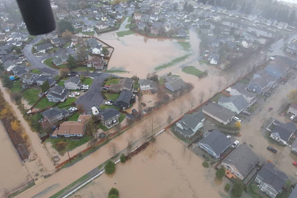
Boise Creek jumped its banks on Dec. 11, not only flooding some city streets but also washing out a part of state Route 410, temporarily cutting off access to Greenwater east of Enumclaw.
Spindor said that the multiple “2-year 24 hour” rain events (where 2.5 inches of rain falls for 24 hours), kept Boise Creek from recovering between the events.
There was significant flooding at 276th Avenue as well as Watson Street and Warner Avenue, specifically near the Mountain Meadow Mobile Homes park, where Jewell Street was “completely inundated.”
Spindor added that there was “[c]onsiderably more flooding that we didn’t have images of that occurred on that day.”
According to a recently-installed United States Geological Survey water gage at the 252nd Avenue bridge, peak flow in Boise Creek exceeded 2,500 cubic feet of water every second.
That’s more than 18,700 gallons of water.
The last high-water event in Boise Creek was recorded in March 2022, when peak Boise Creek flow was at 1,0000 cubic feet every second.
In 2024, the December peak flow of Boise Creek was just over 100 CFS.
PLANNING FOR THE FUTURE
Spindor said the city did all it could to alert residents about the flooding through the city’s website, Public Works’ Facebook page, and via the emergency AM radio station.
Additionally, the city provided 2,000 bags of sand at a Public Works building, plus more sand, bags, and shovels at Suntop Park for residents to use for flood control.
“We dropped it off there in the morning and by the afternoon, all the sand was gone, and all the bags,” Spindor said. “People took advantage of that.”
However, this is about the limit of what the city can do without aid from the King County Flood Control District.
“Ultimately we do need to have an engineering solution for this. I’ll tell you right now, the city has known about this issue for many years. However, this is all out of the city’s jurisdiction. It lies with King County Flood Control District,” Spindor continued. “They have to get in and do… a FEMA flood map of Boise Creek. That will tell us the extent of the flooding, the depth of the flooding, and once we have that information, then we can start making engineering decision about how we address this flooding issue.”
The Flood Control District did start a flood map of the creek “years ago,” Spindor said, but it’s been on hold ever since.
According to Flood Control District Executive Director Michelle Clark, “… [T]he Flood District, in coordination with the City of Enumclaw, reinitiated the Bosie Creek Floodplain Mapping Study this year. We are working with King County to get milestones and an anticipated completion date for the study. Once the study is complete, we will work with FEMA to update their maps.”
Clark added that the plan was put on hold becuase there was “confusion about the purpose and ultimate use of the FEMA maps.”
“It seemed as though some folks thought the maps were unnecessary because they had not experienced any flooding on Bosie Creek,” she continued. “We believe we have addressed those concerns and are ready to move this process forward and begin the Bosie Creek mapping study.”